

Whether you’re driving, hiking, sailing, or simply exploring a new city, understanding your current location can help you plan the best route and avoid getting lost. In an unfamiliar environment, it provides a clear starting point and allows you to make informed decisions about where to go next. Real-time location awareness can also help you track progress towards your destination, reroute in the event of obstacles, and share your position with others for safety.
1- Onlinecompass.net’s “Where am I now?” tool
Navigation tools have become essential to our everyday digital lives. Explore new cities, meet friends in locations, and make sure you are on the correct route while traveling. I know that the current location is important. OnlineCompass.net offers powerful features within a set of tools known as the “Where Am I Now” (CEK Lokasi Saya) tool.

What is the “Where am I now?” tool?
OnlineCompass.net’s “Where Am I Now” tool is a free and easy-to-use feature that uses your device’s GPS and browser location services to identify your exact geographic location. It shows your present:
Latitude and Longitude National/State City County Zip Code Map Location with Zoom feature
This information is displayed in a clear and user-friendly format, making it easy to understand where everyone is, anytime.
How does the tool work?
This tool relies on browser location services and device GPS (Global Positioning System). If you grant permission, this data is used to locate your current location.
A step-by-step guide to using the tool:
Turn on location services: Make sure the location services on your device are turned on. Allow Browser Access: When prompted, allow your browser to access your location. Auto-detect: Your location will be displayed on the map using a blue marker. View detailed data: Latitude, longitude and address details are displayed below the map.
Share your location
An outstanding feature is the ability to share your current location. Simply click the “Share My Location” button and you’ll get an overview of the location data like this:
Latitude and longitude national, city, and county zip codes
This can be shared with others whether you’re using a desktop device or a mobile device.
Zoom and full screen features
This tool provides excellent map customization for user convenience.
Zoom in/out: Use the + and – buttons on the map toolbar to enlarge or zoom out better views of your surroundings. Full Screen Mode: Click the (View Full Screen) button to expand the map to full screen. This is especially useful when exploring or navigating.
Compatibility and Device Requirements
The tool works smoothly on both:
Mobile devices (Android and iOS) Desktop browsers (Chrome, Firefox, Safari, Edge)
There is no need to install the app. Open online oncompass.net and use the tool directly in your browser.
Troubleshooting tips
Does the location not detect? Make sure location services are enabled on your device. Check your browser settings to allow location access. Inaccurate location? Try refreshing the page or using a different browser. On mobile, make sure your GPS is set to Precision mode.
2-My GPS Location: Real-time GPS Application
Finding accurate locations in real time is essential for a wide range of activities, such as hiking in the forest, shaking the earth in the suburbs, sailing along the coast, and trying to remember where you parked your car. One app that promises to do all this with ease is GPS location. Real-time GPS by IgrasoftUG (Haftungsbeschränkt). With over 1 million downloads from over 16,000 users and a 4.5 star rating, the app has proven to be a favorite for people who value accuracy and versatility.
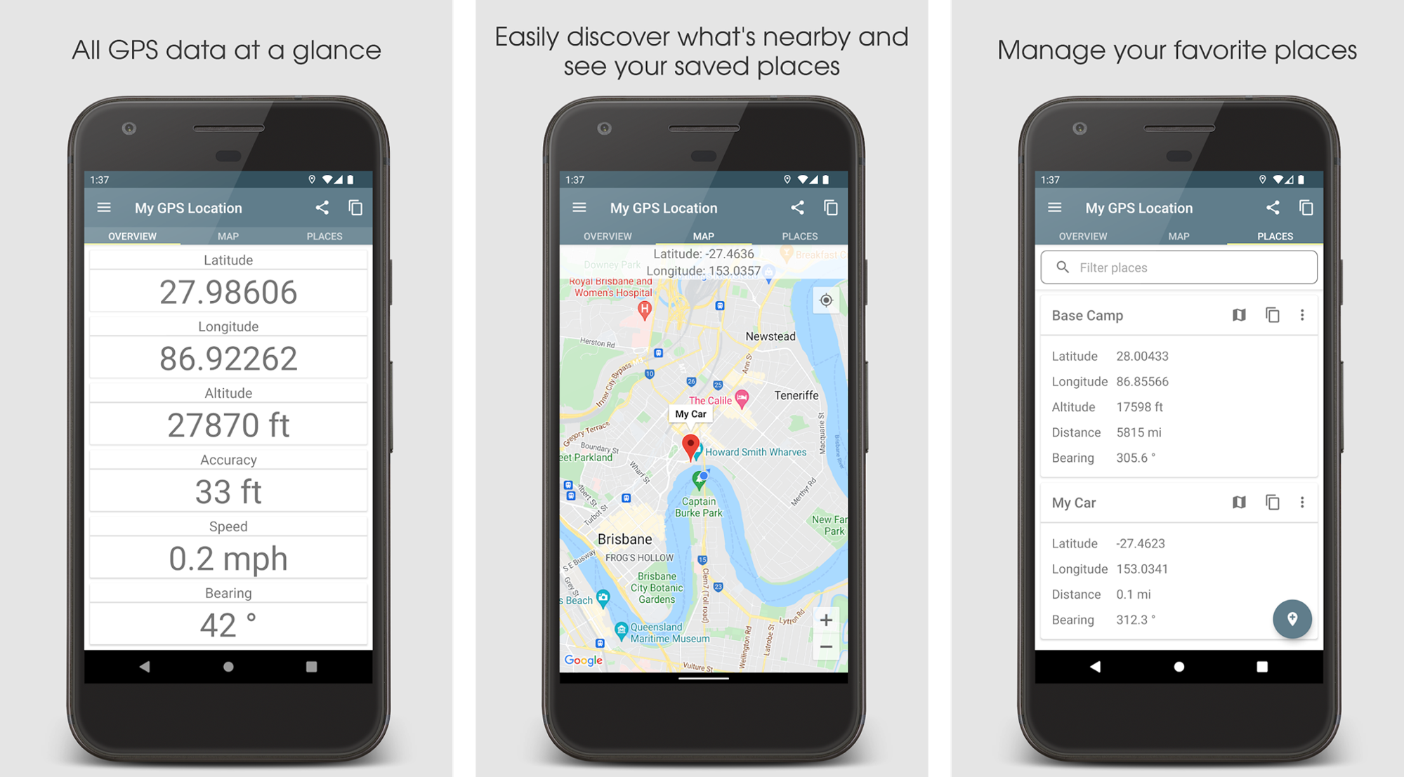
A well-structured interface for smooth navigation
The app is divided into three main tabs: Overview, Maps, and Location. Each section is thoughtfully designed to provide specific features, providing both technical data and user-friendly interactions.
The Overview tab displays the current coordinates, altitude, accuracy, speed, and compass bearings in real time. You can toggle between units such as meters and feet, or view coordinates in decimal, UTM, or DMS format. The Maps tab allows you to view locations in a variety of map styles, including satellites and roadmap views. Long Press can add locations or relocate saved points. The (Places) tab allows you to manage saved locations. You can measure the distance from your current location, change or delete old entries, and create a location history for your trip, fieldwork, or stargaze.
High accuracy and performance in a variety of conditions
One of the most impressive aspects of this app is that it can deliver accurate location data in real time using a combination of GPS, Wi-Fi and cellular signals. During my own testing in both urban and remote environments, I found location updates to be consistently accurate.
Perfect for outdoor enthusiasts, professionals and everyday use
This app is extremely useful for a variety of use cases.
Geocasher appreciates the accuracy and ability to store accurate coordinates. Astronomy and astrophotography enthusiasts can use accurate altitude and position measurements to more effectively align the telescope. Field researchers and surveyors benefit from the app’s ability to log and store specific GPS points. Sailors and sailors can mark anchorages and revisit easily. Travelers and campers can save scenic spots and campsites and easily find them later.
Easily share your GPS location
The outstanding feature is that you can share accurate GPS coordinates with others. Whether you’re trying to let a friend know where to pick you up or in an emergency, this app allows you to send your location right away via messaging apps or SMS. The SMS function works even if there is no data connection. This could be a lifesaver in remote areas.
The app also includes a link to Google Maps in the sharing message, so other people can easily click and see the exact location. For those who frequently remove the grid or enter less populated areas, this feature offers peace of mind.
Emergency preparation and offline support
In emergencies where internet access is not available, SMS-based location sharing in your app is a key feature. Coordinates including latitude, longitude and altitude can be sent via standard text messages. This makes the app extremely useful for hikers, hunters and country explorers.
You can also copy current coordinates to your clipboard and paste them into apps like maps, emails, chats, and more for added flexibility.
Flexible units and coordinate systems
Customization is another strength of this app. You can view your data in several formats to suit your preferences and activity requirements.
Coordinate Format: Decimal, UTM, DMS Distance Unit: Meter or Foot Speed Unit: M/s, km/h, mph, Knot Altitude: Displayed in feet or meters
This level of flexibility makes the app suitable for both casual users and professionals who rely on accurate data.