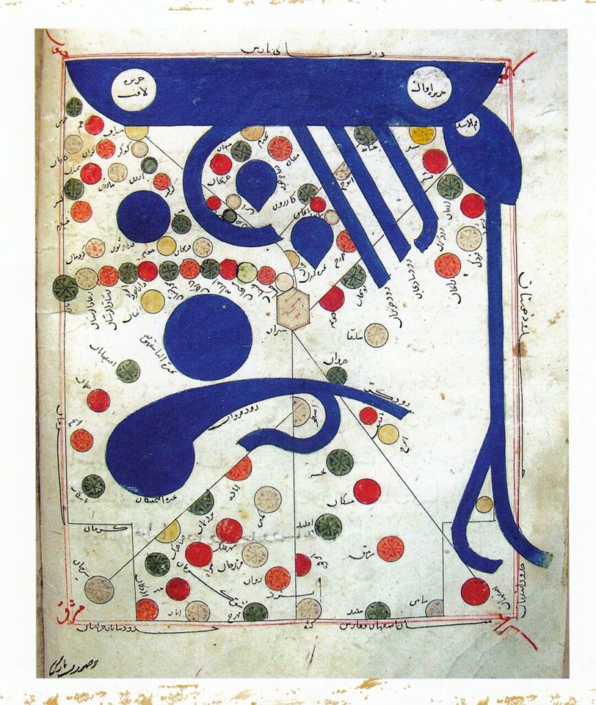
The book on Route and Areas by Ibrāhīm Al-Iṣṭakhrī (Kitābal-Masālikwaal-mamālik) is one of the most important and well-known works in the field of geography.
Al-Iṣṭakhrī wrote the book in Arabic in the 4th century AH (10th century). In this work, he describes the lands of the Islamic world and divides them into 20 regions based on their size.
Also known as Abūisḥāq Ibrāhī, Al-Karkhī, was a well-known geographer of the 4th century AH (10th century) and was originally from Istaful (Persepolis) in the County of Fars. He is considered one of the founders of geographical research in the Islamic world.
The manuscript, held at the National Museum of Iran, is one of the oldest surviving texts of the Seljuk era and the most complete translation of Kitab al-Masarik wa al-Mamarik. This book is most likely translated into Persian under the same title (Masālik Va Mamālik) in the 5th or 6th century AH. Later, 726 AH, Abu al-Masin Moomad Ibn the Ibn Moomad Al Naqyawan, known as Ibn Saudi Arabia, Moomad Al Naqyawan, was transcribed in Isfahan in the Nask script of a government-issued paper (kāghaz-edowlatābādī). The manuscript contains 13 gold and decorated headpieces, 20 color maps, and 2 black and white maps. The binding is cardboard covered in Tīmāj leather with flaps. The front cover has a gold embossedarun (medallion) design.
The manuscript of Masalik Vamamarik’s Persian translation is preserved under Stock number 3515 at the Iranian National Museum of Islamic Archaeology and Arts. This valuable piece is notable for its academic content, the importance of Persian prose, and its hand-drawn color maps. CE (1387 sh), 2008, by recommendations from the Islamic Republic of Iran, this valuable work was registered in 1005 No. 1005 in the memory of UNESCO of the World Commission’s National List.
At Masālik Va Mamālik, Al-Iṣṭakhrī provides detailed descriptions of various countries and regions, including distances, boundaries, valuable commercial products, industries, conditions of different people, historical monuments such as fortresses and temples of fire. The most extensive section of the book is dedicated to Persian lands (Iran). In this manuscript, the map of the Persian Gulf is titled “hūratbaḥrfārs” (image of the Persian Sea), and the map of Iran is titled “hūratbārs” (image of the Persian Sea). It is noteworthy that the word “shara” (image) in this book refers to a map.
morning

